
The Via de la Plata or the Silver Route is one of the toughest and longest Camino de Santiago routes in Spain. The distance of the route, over 1000 km/621 mi is the main challenge. Long walking stages with few facilities in between, and extremely hot weather in the summer months are two other factors that make it even more difficult. The route crosses four Spanish regions; Andalusia, Extremadura, Castilla y Leon, and Galicia. The route is a great combination of beautiful countryside scenery, impressive Roman ruins, and spectacular medieval cities and towns.
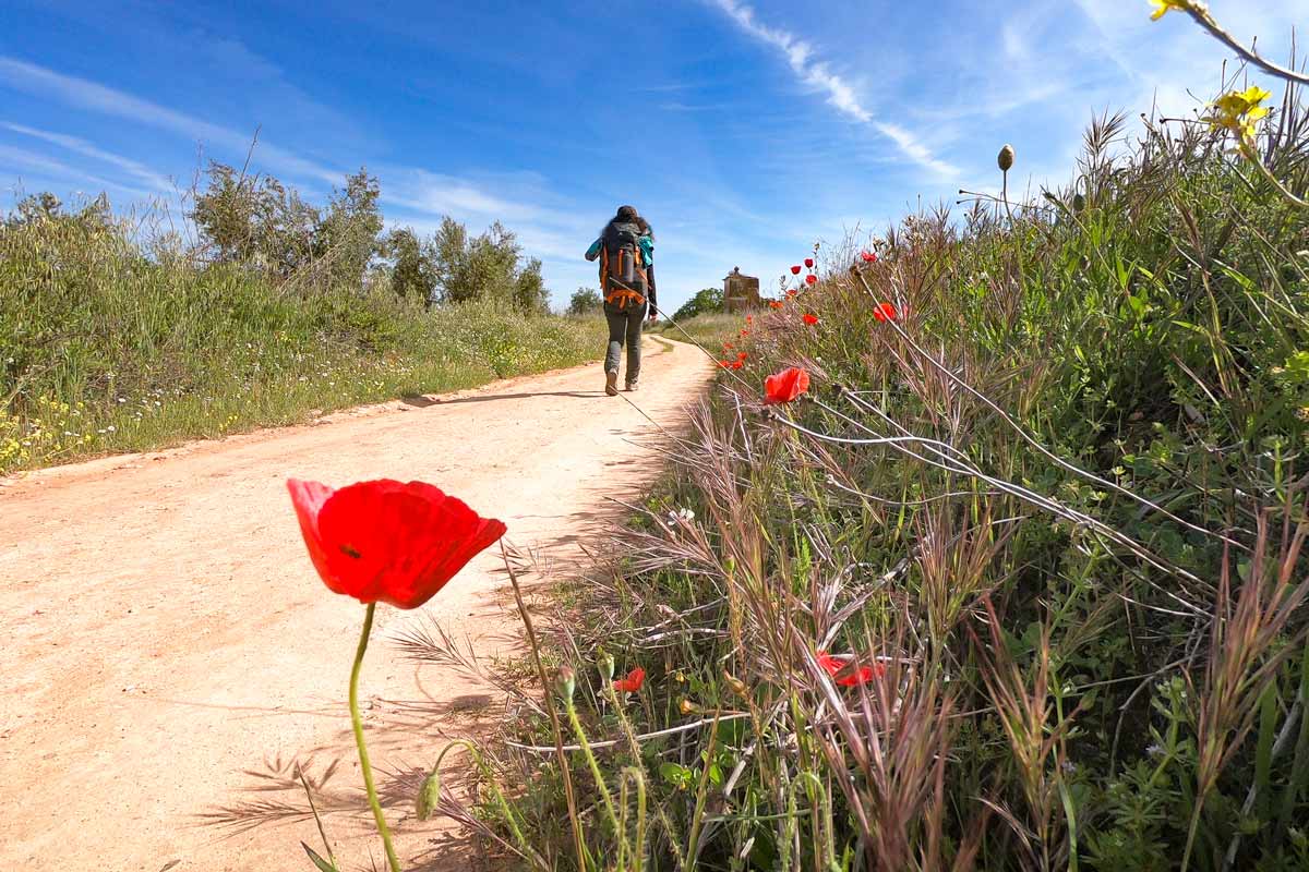
 Alya walking through the fields covered in poppies in April on the Via de la Plata
Table of Contents
Toggle
- Via de la Plata PDFs
- GPX files for the Via de La Plata
- What is Via de la Plata?
- How long is the walk?
- How difficult is the route?
- Vía de la Plata routes
- Best months for walking
- Via de la Plata cost
- What to pack for the Camino?
- Via de la Plata guidebooks
- Luggage transfer
- What is the accommodation like?
- Seville, the start of the Via de la Plata
- How to get to Seville?
- Via de la Plata walking stages (Seville to Mérida)
- The route overview
- Stage 1. Seville – Guillena, 23 km/14 mi
- Sage 2. Guillena – Castilblanco de los Arroyos, 18 km/11 mi
- Stage 3. Castilblanco de los Arroyos – Almadén de la Plata, 28,7 km/18 mi
- Stage 4. Almaden de la Plata – Monesterio, 35 km/21,7 mi
- Stage 5. Monesterio – Fuente de Cantos, 20,6 km/12,8 mi
- Stage 6. Fuente de Cantos – Zafra, 24,7 km/15,3 mi
- Stage 7. Zafra – Villafranca de los Barros, 20,5 km/12,7 mi
- Stage 8. Villafranca de los Barros – Torremejía, 27,5 km/17 mi
- Stage 9. Torremejía – Merida, 15,6 km/9,6 mi
- Vía de la Plata planning resources
- Questions or Comments?
Via de la Plata PDFs
To make your planning easier we’ve created two PDFs. The first one contains walking stages on the Via de la Plata and the second one lists places to stay along the route. We’ve completed only the first part of the Via de la Plata from Seville to Merida. The PDFs contain information only for that part. We’re planning to walk the rest of the route in 2025/26 and will update the post.
GPX files for the Via de La Plata
You can download our GPX files for the part of the route from Seville to Merida. Check out our detailed guide on How to use Stingy Nomads GPX files to navigate with your phone.
Our walk on the Via de la Plata from Seville to Merida
What is Via de la Plata?
The Via de la Plata is one of the longest Camino de Santiago routes in Spain. It starts in Seville, Andalusia, crosses Spain from south to north, and finishes in Santiago de Compostela, Galicia. In Roman times, the route was used to transfer goods from the south to the north of Spain. Nowadays it’s one of the toughest and least walked pilgrimage routes to Santiago. In 2024 only 1,8% (9028 people) of all the pilgrims who arrived in Santiago de Compostela walked the Via de la Plata.
Like on any other Camino route, you’ll need a Credential (a pilgrim’s passport) to be able to stay in public albergues and to get the Compostela certificate in Santiago de Compostela.
Travel insurance for the Camino
A long-distance walk like any other outdoor activity involves a risk of getting an injury or sickness. The Via de la Plata is a very long and challenging route often through remote areas with no towns or villages for 20km. Small injuries and traumas such as blisters, shin splints, and sprains are quite common. Get more information about travel insurance for the Camino in our dedicated post or get an instant quote right here.
World Nomads offers simple and flexible travel insurance. Buy at home or while traveling and claim online from anywhere in the world.
How long is the walk?
The total distance of the Via de la Plata is 1000 km/621 mi. It takes between 40 and 50 days to complete the route depending on your daily distances and number of rest days in between.
How difficult is the route?
We’ve walked 11 Camino de Santiago routes and I’d say judging on the first part of the Via de la Plata it’s more challenging. The main reason is the long distances between towns and villages which means you have to carry a lot of water and some snacks with you.
There are no steep ascents or descents on this route like on the Camino Primitivo or the Northern Way, but long distances, both daily and the total distance over 1000 km/621 mi, combined with little infrastructure in between and high temperatures make the Via de la Plata a difficult route.
Any long trekking/walking route is challenging because it takes many days or even weeks to complete, but when it’s more than 1000 km/621 mi it gets very long.
Long stages and walking through nothing is another challenging part of the route. We had days when we walked for 20-25 km/12-15 mi through nothing. Not even a place to refill your water!
If you want to walk the Via de la Plata and have never done a long-distance walk before you can start in Seville and see how far you get. Once you don’t feel like walking anymore, you can stop and continue sometime later.
 One of many churches on the Via de la Plata route
Vía de la Plata routes
The Vía de la Plata has several routes and connecting trails with other Camino routes.
- It’s possible to start in Granada or Almería, walk to Mérida following the Camino Mozárabe, and from there continue on the Vía de la Plata to Santiago. This route is very long, over 1200 km/745 mi.
- Another option is to start in Valencia, walk to Zamora following the Camino de Levante, and from Zamora continue to Santiago de Compostela on the Vía de la Plata. This route is even longer, 1300 km/807 mi.
- The Vía de la Plata splits after Zamora; one route goes north to Astorga where it merges with the Camino Frances; another route goes north-west through Ourense following the Camino Sanabrés. If you decide to walk through Astorga, be ready to see many pilgrims, the French Camino is the most popular route, especially the last 100 km/62 mi to Santiago de Compostela.
If you decide to walk the Camino Mozárabe or the Levante it’s important to remember that these routes are not very popular with very few pilgrims. As a result, they have less infrastructure than the well-established Camino routes; finding accommodation might be challenging in some parts. You’ll need some basic Spanish to be able to explain simple things. Both routes go through non-touristy parts of Spain with very few people speaking English.
Best months for walking
Let’s start with the worst time because unlike with the other Camino routes, summer is the worst time to walk the Via de la Plata; because it gets incredibly hot. July, August, and September are the worst months. The temperature is between 40°C and 45°C, with no shade to hide, not a drop of rain, clear skies, and nowhere to get water along the route (sometimes you walk 20-25 km through nothing).
June is hot and sunny most of the time but not as scorching hot as in July, August, and September.
Our favorite time for Via de la Plate is spring. April and May are the best months for the Camino; it’s warm but not hot, not much rain, the fields are covered in flowers, the area is very green, the air is fresh. Weatherwise October is close to these two months just the fields are dry.
As for walking the Via de la Plata offseason, November – March, it might be a good idea if you want to make sure it’s not going to be hot but it rains quite a lot in January, February, March. You might feel lonely as there will be very few pilgrims on the route.
 Green fields in spring on the Via de la Plata
Via de la Plata cost
Accommodation. Public albergues on this route are more expensive than on the other Camino routes. You usually pay 10€ per bed in a public albergue. On the Via de la Plata the standard price is 14€. From Seville to Mérida we got only one albergue for a donation and a couple for 10€, the rest were 12-14€. Private albergues/hostels cost between 15€ and 20€.
Food. A good thing about this route was that every town we stopped had a least a small shop but usually, there was a supermarket where we could make food. Prices in supermarkets here are similar to the rest of Spain if you buy food for two meals it’ll cost you between 8€ and 10€ per person depending on what you buy.
Remember that in Spain supermarkets are closed on Sundays, public holidays, and often for lunch, between 2 pm and 5 pm.
Eating out. Traditional Menu del Día (a set menu with first, main, drink, bread, and coffee/dessert) for 12€ is quite popular. A cup of coffee and a sandwich with Jamón or cheese and tomato (Tostada) cost about 4€. The coffee is good and cheap, Americano costs less than 1€, Cafe con Leche (Cappuccino) about 1,5-2€. A beer or a glass of wine (cheap wine) in a bar is about 2€, it usually comes with chips, olives, or peanuts.
Transport. To get to Seville, the starting point of the route you can take a bus or a train from Madrid or other cities/towns in Spain or Portugal. A bus from Madrid to Seville costs 25€, the journey takes 6h30min. A speed train is from 45€, it takes 2h50min.
Our Via de la Plata budget breakdown (9 days, 2 people)
We stayed in dormitories in public and private albergues, only one night in a private room in a hotel, bought food in supermarkets (most of the time), usually stopped for breakfast and coffee (one to two times a day), a couple of times went out for a beer or wine.
- Accommodation – 300€
- Eating out (food, coffee, etc.) – 150€
- Shopping (food) – 110€
- Transport (bus Madrid – Seville) – 50€
- Laundry – 10€
Total: 620€ or 34€ per person per day.
What to pack for the Camino?
It’s important to remember not to overload your pack. It’s a very long route, you’re going to walk for more than one month with your backpack. Depending on what time of the year you decide to walk the Via de la Plata you’ll need different essentials. If you walk the route in fall/winter when it rains quite a lot in Andalusia and Extremadura you’ll need a rain poncho and a pair of good waterproof hiking boots.
For the spring/summer season good sun protection is important, make sure to pack a cap or better a hat, sunglasses, sunscreen, and two water bottles so that you have at least 2l of water per person.
We have a detailed Camino de Santiago packing guide where you can find the essential packing list for men and women for different seasons.
Via de la Plata guidebooks
On such a long Camino route like this one, it’s great to have a nice book. If you like reading having a Kindle might be a good idea. You can upload as many books in your language as you want.
It’s not always easy to find books other than Spanish languages on the route. If you read a lot it might be worth joining the Amazon Kindle Unlimited program that gives you free access to thousands of e-books and audiobooks. You don’t need a Kindle device to use the program with the Amazon free reading app you can use it on your phone or tablet.

 The Acueducto de los Milagros, an old Roman Aqueduct in Mérida, our last stop on the Via de la Plata
Luggage transfer
It’s possible to arrange luggage transfer on the Via de la Plata. Your backpack or suitcase will be transferred from place to place. You can use it for the entire route (which will increase the cost of the walk quite a bit) or only for longer stages when you have to walk over 30 km/18,6 mi.
It works easy; a company picks your luggage up at the reception in the morning and drives it to the next accommodation place. By the time you arrive, your backpack is already there.
Several companies offer luggage delivery; Correos, Mundicamino, Pilbeo (from Ourense). The price is between 7 and 8 Euros per backpack per stage.
What is the accommodation like?
Like on any other Camino route the main accommodation for pilgrims on the Via de la Plata is albergues. Albergues can be private and public. Public albergues are run by municipalities and usually are the cheapest places to stay on the Camino. These albergues are exclusively for pilgrims who walk or cycle the Camino.
Private albergues belong to a person or a company, they are a bit more expensive than public ones and usually have better facilities. Private albergues are more like hostels anybody can stay there but most of the guests are usually pilgrims. There are hotels and guest houses along the route as well in case you prefer staying in private.
Comparing public and private albergues
| Features | Public albergues | Private albergues |
|---|---|---|
| Exclusively for pilgrims | yes | no |
| Need a Credential | yes | no |
| Can be booked | no | yes |
| Accept cards | no | sometimes |
| Allow luggage delivery | no | yes |
| Price | 12-14 Euro | 15-20 Euro |
Public vs private albergues on the Via de la Plata
Seville, the start of the Via de la Plata
Seville is a beautiful city with a lot to see and to do, spending here a couple of days before starting the Camino is a great idea. My favorite way to spend time in Seville is sitting at one of the street restaurants near the Cathedral with a glass of wine and a couple of delicious tapas.
Things not to miss in the city: Plaza de España, Royal Alcázar, Cathedral, La Giralda, Torre de Oro, Parque de María Luisa, Santa Cruz barrio (neighborhood), Triana neighborhood, Plaza de Toros, Casa de Pilatos.
Seville tours & activities
There are many great tours around the city and to the nearby attractions.
Places to stay in Seville
There is no public albergue in Seville but there are several hostels and private albergues. They are not exclusively for pilgrims anybody can stay there but most of the people staying at albergues are pilgrims.
We stayed at El Viajero en Sevilla, a small hotel in the historical center. It’s a great place, very neat, comfortable, and cozy. If we go to Seville we’ll stay here again.
Note! If you arrive in Seville during the Semana Santa a week before Easter), book your tickets and accommodation well in advance.

 The Santa Cruz neighborhood from the Giralda, the bell tower of Seville Cathedral
How to get to Seville?
There is an international airport in Seville. You can find direct flights from many European countries (UK, Germany, France, Italy, Switzerland, etc.) as well as from several Spanish cities (Madrid, Barcelona, Valencia, Bilbao, etc.( .If you buy tickets in advance you can fly for as little as 20-40 Euro. Ryanair, EasyJet, Iberia Express, and Vueling are the main airlines that offer flights to Seville.
Getting to Seville from Madrid
If you come from overseas, Madrid is probably the best city to fly. From Madrid, you can catch a direct flight, a train, or a bus to Seville. Flying is the fastest way of getting there. There are regular buses and trains as well.
Madrid to Seville – transport options
| Madrid to Seville | Flight | Train | Bus |
|---|---|---|---|
| Daily departures | 5 | 8 | 3+ |
| Station | Barajas airport | Puerta de Atocha | Barajas T1 Estacion Sur |
| Time to get | 1h10min. | 2h40min. | 6h20min. |
| Ticket price | from 30 Euro | from 40 Euro | 34 Euro |
| Company | Iberia, Iberia Express | RENFE | Socibus |
Comparing different ways of getting to Seville from Madrid
Getting to Seville from Barcelona
If you land in Barcelona I recommend flying to Seville. A direct flight from Barcelona takes 1h45min. Prices start at 31 Euro. Ryanair and Vueling are two airlines that offer direct flights.
A direct fast train (5h30min.) from Barcelona to Seville costs 120 Euro. You definitely will be able to find cheaper flights. There is a cheaper train, 65 Euro but it takes 11h30min. There are no direct buses from Barcelona to Seville, you’ll have to go via Albacete, the journey takes more than 15 hours.
Via de la Plata walking stages (Seville to Mérida)
We’ve walked only 9 first stages on the Via de la Plata, from Seville to Mérida, here you can find a detailed itinerary for these days. We’re planning to finish the route next year and will update the post after that.
| Day 1 Seville – Guillena 23 km/14 mi |
Day 2 Guillena – Castilblanco 18 km/11 mi |
Day 3 Castilablanco – Almadén de la Plata 28,7 km/ 18 mi |
| Day 4 Almadén de la Plata – Monesterio 35 km/21,7 mi |
Day 5 Monesterio – Fuente de Cantos 20,6 km/12,8 mi |
Day 6 Fuente de Cantos – Zafra 24,7 km/15,3 mi |
| Day 7 Zafra – Villafranca 20,5 km/12,7 mi |
Day 8 Villafranca – Torremejía 27,5 km/17 mi |
Day 9 Torremejía – Mérida 15,6 km/9,6 mi |
Vía de la Plata stages Seville – Mérida
The route overview
- Total distance – 214 km/132 mi
- The time required – 8-10 days
- Starting point – Seville
- Finishing point – Mérida
- Total ascent (in 9 days) – 2976 m
- Total descent – 2766 m
- Walking surface – mostly gravel road – 160 km/99 mi, asphalt – 54 km/33 mi
- Route marking – yellow shells and arrows
- Average cost – 35€ per person per day
- Accommodation – public and private albergues, hotels
Stage 1. Seville – Guillena, 23 km/14 mi
- Time – 5 hours (moving time)
- Walking on the road – 3 km/1,8 mi
- Walking on asphalt – 10 km/6,2 mi, the rest on footpath/gravel
- Ascent – 158 m
- Descent – 124 m
- Difficulty level – 2 out of 5

 Elevation profile stage 1 Seville – Guillena
The walk starts from the cathedral in Seville, there are a couple of yellow arrows and a shell at the corner of Avenida de la Conctitución and Calle García de Vinuesa. To our surprise it was quite easy and quick to walk out of the city, it took us about 30 min. and we didn’t go through any industrial or residential areas of the city. Most of the day the route went through the fields but there was an unpleasant walking on the road for about 3 km/1,8 mi after Santiponce.
Santiponce is the only town on the way, it’s about 9 km/5,5 mi from Seville and it’s worth stopping here and visiting the famous Roman ruins; the Roman Therms and the Roman Amphitheatre. The Amphitheater, by the way, was featured in season 7 of Game of Thrones as the Dragonpit. Unfortunately, we couldn’t visit them because it was closed on Monday. For more information on the ruins of Italica and opening hours visit the official website.
If you want to stop for lunch Santiponce is the only place on the way, don’t forget to refill your water there will be nowhere to do it till Guillena.
Highlights
- Stunning Gothic cathedral of Seville
- Triana district in Seville
- The Roman ruins of Italica, Santiponce
Challenges
- 3 km/1,8 mi of walking on the road after Santiponce
- No places to stop or to refill water between Santiponce and Guillena, for 13 km/8 mi
Guillena
A small town with good infrastructure though we were here on Sunday and everything was closed.

 Typical scenery on the Via de la Plata; fields, olive tree plantations, and a gravel road
Sage 2. Guillena – Castilblanco de los Arroyos, 18 km/11 mi
- Time – 4 hours
- Walking on the road – 0 km, the last 3 km/1,8 mi are on the footpath next to the road
- Walking on asphalt – 2 km/1,2 mi
- Ascent – 386 m
- Descent – 91 m
- Difficulty level – 2 out of 5

 Elevation profile stage 2 Guillena – Castilblanco de los Arroyos
We didn’t pay for breakfast in the albergue we stopped on the way at one of the local bars S.C.A. Kibarpe, next to the supermarket Dia, they have good coffee and sandwiches, we paid 5 Euro for both.
It was a relatively short and easy walking day with a slight ascend of about 386 m throughout the day. In the beginning, you walk through Guillena town till the bridge, then cross the bridge after that turn right, away from the road, and there will be a Camino sign. The route through the town is not marked very well, here and there you see an arrow but it’s not difficult you basically just follow the main street from the albergue all the way out.
At about 3 km/1,8 mi after crossing the road you get to a very muddy path through the olive tree plantations. At about 8 km/5 mi a beautiful forest substitutes the plantations. There are no villages on the way no places to stop for coffee or food. At 10 km/6,2 mi there is a place to refill water you won’t miss it there is a big sign on the right-hand side. The last 3 km/1,8 mi before Castilblanco are on the footpath along the road.
Highlights
- Walking through the forest and the fields
- Castilblanco is a charming town with traditional white houses and cobbled streets
- Communal dinner at the albergue
Challenges
- A very muddy and slippery path between 3 km/1,8 mi and 5 km/3 mi
- Nothing between Guillena and Castilblanco
Castilblanco de los Arroyos
A nice small town with several bars and restaurants on the main street and a beautiful church with many storks’ nests on the roof.
Stage 3. Castilblanco de los Arroyos – Almadén de la Plata, 28,7 km/18 mi
- Time – 6-7 hours
- Walking on the road – 16,5 km/10,2 mi
- Walking on asphalt – 16,5 km/1-,2 mi
- Ascent – 649 m
- Descent – 521 m
- Difficulty level – 3 out of 5

 Elevation profile stage 3 Castilblanco de los Arroyos – Almadén de la Plata
I’d suggest making sure you have enough water before you leave Castilblanco as well as taking some snacks with you and having breakfast in the town before you leave. There is literally nothing on the way; no place to refill water, no place to buy food till you reach Almadén de la Plata.
It was quite a long day of walking. The first part was on the road after an hour or so it got quite monotonous but it wasn’t as bad as we thought, the road was not very busy. The second part, after 16,5 km/10,2 mi, is through Natural Park Sierra Norte. The scenery in the park is beautiful; green hills, trees, many flowers (in spring), and a couple of smallish rivers. Unfortunately, we couldn’t really enjoy the scenery as it was raining non-stop all the time we were in the park.
Highlights
- Natural Park Sierra Norte
Challenges
- Walking on the road for the first 16,5 km/10,2 mi
- No place to stop for food or water for 28 km/17,3 mi
- Steep but not long ascent just before Almadén de la Plata
Almadén de la Plata
This town is smaller than Castilblanco, it has a couple of restaurants and shops, a square with a church, and a Jamon factory.

 Sierra Norte Natural Park is a patch of green forest on the Via de la Plata.
Stage 4. Almaden de la Plata – Monesterio, 35 km/21,7 mi
- Time – 8 hours
- Walking on the road – 2 km/1,2 mi short bit here and there on the last 8 km
- Walking on the asphalt – 4 km/2,4 mi through the towns and a little bit along the road
- Ascent – 850 m
- Descent – 575 m
- Difficulty level – 4 out of 5 it was a long walking day

 Elevation profile stage 4 Almadén de la Plata – Monesterio
Option! If you think walking 35 km/21,7 mi in one day is too much you can split this day into two. Walk 13,5 km/8,3 mi to Real de la Jara and the next day 21 km/13 mi to Monasterio.
A second long day in a row, most pilgrims we started with walked 13 km/8 mi and stayed in Real de la Jara, many people split this day into two. At the beginning of the day, we continued walking through Natural Park Sierra Norte with beautiful scenery and many smallish ups and downs.
Luckily, today there are two stops on the route so you can put down your backpack and sit down, drink coffee, eat something, and refill your water. At Real de la Jara you leave the region of Andalusia and enter Extremadura.
The last 8 km are next to the road mostly on the footpath crossing the road here and there.
Highlights
- A beautiful walk through the countryside and forest
- The castle in El Real de la Jara
Challenges
- A long walking day, 35 km/21,7 mi and it did feel long and tiring.
Monesterio
Don’t be confused by the name, the actual monastery is 5 km/3 mi outside the town you won’t see it unless you walk there or take a taxi. The town itself is quite big compared to most towns on the Via de la Plata.

 Ruins of a castle just outside El Real de la Jarra on the border between Andalusia and Extremadura
Stage 5. Monesterio – Fuente de Cantos, 20,6 km/12,8 mi
- Time – 5 hours
- Walking on the road – 0 km
- Walking on the asphalt – 2 km/1,2 mi through the towns
- Ascent – 291 m
- Descent – 432 m
- Difficulty level – 2 out of 5

 Elevation profile stage 5 Monesterio – Fuente de Cantos
We started the day quite late, it took us about 10 min. to walk out of the town, at the exit there is a restaurant that opens at 7 am, they have coffee or hot chocolate with churros for 3 Euros. Make sure to have enough water and there will be nothing on the way. The walk was easy and nice with light ups and downs, through a very quiet countryside with olive tree plantations, wheat fields, cows, sheep, etc. far from the road and any other disturbing noises.
Highlights
- Very peaceful area with no people, cars, or houses only fields and nature.
Challenges
- Nothing on the way for 20 km/12,4 mi you have to carry enough water with you for the whole day.
Fuente de Cantos
A cozy little white town with a small square and a church on it and narrow cobblestone streets.
Hotel El Zaguán de la Plata
An amazing old house with several rooms, a lovely garden, a swimming pool, and an awesome shower – one of our favorite places on the Camino. They have special prices for pilgrims. Price 15€ per person for private, 12€ per bed in a dormitory.
- Kitchen – yes
- Hot shower – yes
- Wi-fi – yes
- Power sockets in the room – yes
- Blankets – yes
- Washing machine – yes, 2 Euro
- Extra – dryer – 3 Euro, washing lines, swimming pool, garden
Stage 6. Fuente de Cantos – Zafra, 24,7 km/15,3 mi
- Time – 6 hours
- Walking on the road – 0 km
- Walking on the asphalt – the last 4 km/2,4 mi to Zafra
- Ascent – 212 m
- Descent – 288 m
- Difficulty level – 2 out of 5

 Elevation profile stage 6 Fuente de Cantos – Zafra
It was an easy walking day through the countryside most of the time make sure to have enough water between 6 km/3,7 mi and 20 km/12,4 mi there is nothing on the way except a shelter at 15 km/9,3 mi where you can stop and rest, drink water or eat something.
Highlights
Peaceful scenery; olive tree plantations, vineyards, pasture fields, etc.
The historical center of Zafra; Plaza Grande, Plaza Chica, Convento de Santa Clara. If you happen to be here on the weekend go to one of the squares and drink a glass of wine or beer, there are many restaurants and bars here, and on weekends they are full of locals, it has a great holiday vibe.
Challenges
- 14 km in the middle of the day with nothing on the way
Zafra
It’s more of a city place, much bigger than other stops on the way. The historical part of Zafra is nice; cobblestone streets, two beautiful squares, a cathedral, a fortress, and several small parks.

 Alya in the wheat fields, the dominating scenery on the Via de la Plata in Extremadura
Stage 7. Zafra – Villafranca de los Barros, 20,5 km/12,7 mi
- Time – 5 hours
- Walking on the road – 400 m
- Walking on asphalt – 8 km/5 mi; the first 7 km/4,3 mi from Zafra and the last 1 km/0,6 mi
- Ascent – 246 m
- Descent – 339 m
- Difficulty level – 1 out of 5 a short and easy walking day

 Elevation profile stage 7 Zafra – Villafranca de los Barros
It was an easy walking day except for the very beginning, the route through Zafra is not marked very well, and everybody got a bit lost (we left first and stopped at a bar for breakfast and could see other fellow pilgrims wandering around in search of yellow arrows), in the end, we had to ask locals.
We followed the arrows to the Plaza Grande and then lost them, the same happened to everybody. I’d suggest once you’re on the Square ask around will point you the right way. You walk out of the town following Calle San Francisco you can find it on the map.
The rest of the day was very similar to the previous two walking days. After 4,5 km/2,7 mi there is a small town where you can stop for coffee, it’s the only stop on the route.
Highlights
- Cathedral and cobblestone streets of Los Santos de Maimona
- Olive tree plantations and vineyards
Challenges
Nothing on the way for 15 km/9,3 mi between Los Santos de Maimona and Villafranca de los Barros, make sure to carry enough water as the route goes through the fields with no shadow.
Villafranca de los Barros
A typical town with a square, a couple of churches, and many restaurants and bars. We were here on Sunday everything was closed even restaurants didn’t serve food between 4 pm and 8.30 pm because kitchens are closed at this time of the day.
Stage 8. Villafranca de los Barros – Torremejía, 27,5 km/17 mi
- Time – 6-7 hours
- Walking on the road – 0 m
- Walking on the asphalt – 3 km/1,8 mi in the towns
- Ascent – 105 m
- Descent – 221 m
- Difficulty level – 3 out of 5, a long walking day with no places to stop for food or water

 Elevation profile stage 8 Villafranca de los Barros – Torremejía
Note! There is a town Almendralejo about halfway with a couple of hotels but it’s 4 km/2,4 mi off the route to get there and then back on the Camino you’ll have to walk 8 km extra.
The walk wasn’t difficult but it’s quite long we’d strongly recommend starting walking early to skip the midday heat. We walked the Via de la Plata at the end of April and it was already quite hot after 10 am. Make sure you have enough water to last you the whole day there will be no place to refill it. The scenery was very similar to the previous days; vineyards, olive trees, fields, and not much else.
Highlights
- Beautiful sunrise on the way out of the town (if start early enough).
- Vineyards and olive tree plantations, to be honest after a couple of days this scenery started to get quite monotonous.
Challenges
- Quite a long distance with no places to stop or to refill water on the way.
Torremejía
Another small white town with a couple of hotels, one albergue, restaurants, and supermarkets.
 A typical scenery in the first half of the Via de la Plata
Stage 9. Torremejía – Merida, 15,6 km/9,6 mi
- Time – 4 hours
- Walking on the road – 2 km/1,2 mi
- Walking on the asphalt – 5 km/3,1 mi
- Ascend – 79 m
- Descend – 175 m
- Difficulty level – 1 out of 5, short and easy walking day

 Elevation profile stage 9 Torremejía – Mérida
To walk out of the town you can go left from the albergue and follow the gravel road for a little bit or go right towards the restaurant and follow the road, both routes join after about 500 m. It wasn’t the most beautiful walking day, the first half was along the road, sometimes on the road, the second half past some sort of industrial area or factories. And again nowhere to stop on the way we’d recommend having breakfast in Torremejía and carrying enough water.
Highlights
- The Roman bridge at the entrance to Merida
- Several Roman ruins in Merida; aqueduct Los Milagros, Roman Theatre and Amphitheatre, Circo Romano, Alcazaba.
Challenges
- at the beginning of the day 2 km/1,2 mi of walking on the road out of 7 km/4,3 mi of walking next to the road.
Merida
It’s a World Heritage city with several impressive Roman sights. If you have time I’d suggest stopping here for 2 days if not try to start walking early in the morning to have more time to explore the city. We stayed for 2 nights here; the first night at the municipal albergue Molino de Pancaliente and the second is a guest house.
Merida seems to be quite a popular place to start the Camino there are more pilgrims here than in the previous towns on the way. It’s another reason to start earlier to get a spot in the albergue, there are only 16 beds and it’s the only budget accommodation in the city. Like in any other public albergue you can stay here only for one night.
We finished the Via de la Plata in Mérida where we stayed for 2 days to have time to explore the Roman ruins. From Merida, we went to Portugal where we spent two weeks walking the Fisherman’s Trail, a spectacular coastal route in the south.
We’re planning to finish the Via de la Plata one day.

 Campbell on the Puente Romano, an old Roman bridge at the entrance to Mérida
Vía de la Plata planning resources
Questions or Comments?
Got any questions or comments? We would love to help! All questions and comments will be answered by us personally in Buy Me a Coffee. Click below and ask away.
Feel free to support our site by buying us a coffee!


The pretty half of Stingy Nomads, responsible for all our land adventures (hiking, climbing, walking the Camino) and following them write-ups. Alya loves walking since she was a child, she prefers to walk 1000 km with a backpack rather than to do a 10 000 km road trip (actually any road trip). Alya is a big fan of Latin America, the Spanish language, and dancing. Every time we go away she desperately misses our dog Chile.
Please visit:
Our Sponsor