
The Camino de Santiago is a popular pilgrimage route in Europe. Every year it attracts thousands of people from all over the world. There are many routes of different lengths and difficulties that lead to Santiago de Compostela. Not everybody has the possibility to complete the Camino de Santiago; most of them require between two weeks and one month. That’s why many people choose to walk the last 100 km/62 mi to Santiago.
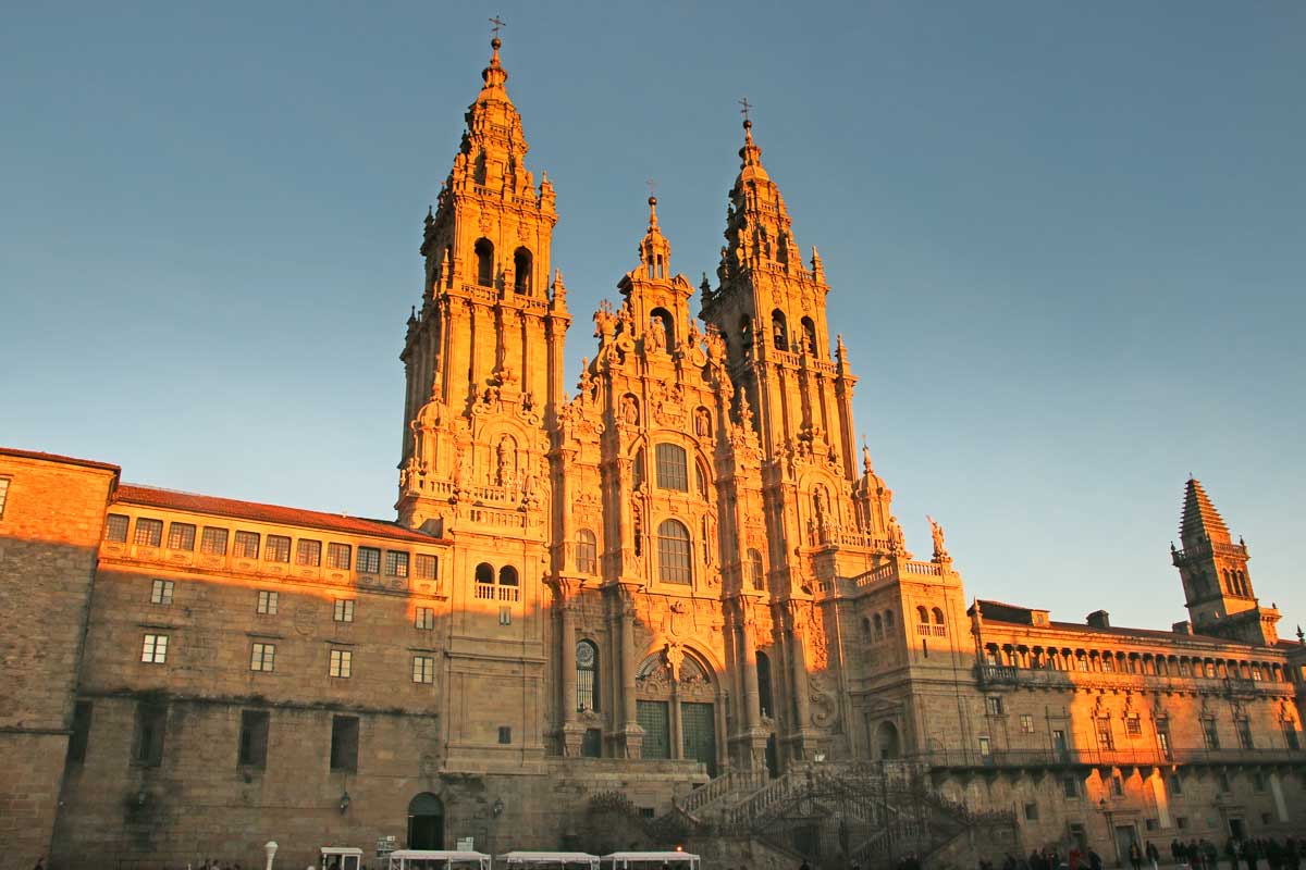
 The Cathedral of Santiago de Compostela, the end of the last 100 km pilgrimage on the Camino
Table of Contents
Toggle
- The three most popular Camino routes to walk the last 100 km
- Why the last 100 kilometers?
- Two stamps per day for the 100 km
- The best time for walking
- The last 100 km to Santiago on different Camino routes
- Camino Frances from Sarria, 116 km/72 mi
- Portuguese Camino from Tui, 119 km/74 mi
- Camino Inglés from Ferrol, 116 km/72 mi
- Camino Primitivo from Lugo, 102 km/63 mi
- Camino del Norte from Baamonde, 102 km/63 mi
- Camino Sanabrés (Via de la Plata) from Ourense, 102 km/63,3 mi
- Camino de Invierno from Chantada, 103 km/64 mi
- Camino Finisterre-Muxia from Santiago de Compostela, 115 km/71,4 mi
- Which route is the best to walk the last 100 km?
- Camino de Santiago planning resources
- Questions or Comments?
The three most popular Camino routes to walk the last 100 km
These three Camino routes are by far the most popular to walk the last 100 km/62 mi.
- Camino Frances from Sarria – 151 093* people or 31,9% of all pilgrims who arrived in Santiago in 2024.
- Camino Portuguese from Valença/Tui – 36 576 people or 7,7% of all pilgrims.
- Camino Ingles from Ferrol – 26 782 people or 5,6% of all pilgrims.
*According to the Pilgrim’s Reception Office in Santiago
If you have some time after completing the Camino I suggest spending a couple of days exploring the city and its surroundings there are many amazing things to do in Santiago de Compostela.
Why the last 100 kilometers?
There are no actual rules for walking the Camino. You can walk any part you want. The 100 km rules is applicable if you want to get the Compostela, a certificate issued to any pilgrim who completed at least 100 km/62 mi on any official Camino de Santiago route.
Note! The required distance used to be the last 100 km/62 mi to Santiago but in 2025 the rules were changed.
To get the Compostela in 2025 a pilgrim should
- walk any 100 km/62 mi on one of the officially recognized Camino de Santiago route.
- walk at least the last stage to Santiago de Compostela on the chosen route.
- walk at least 70 km/43 mi out of 100 km/62 mi through Spain. It means you can start walking on a Camino route in a different country but most of your walk should be through Spain.
As a confirmation, every pilgrim must have a Credential (a pilgrim’s passport) with stamps collected from different albergues, churches, restaurants, etc. along the route. If you walk only a 100 km/62 mi you should collect to stamps per day.
If you’re not interested in getting the Compostela you can walk the Camino they way it suits you. The route is marked and accessible to anybody. You can walk only one day, or two weeks, starting in the middle, walking it in the opposite direction, etc. Just remember if you’re planning to stay in public albergues you’ll need a Credential with stamps to confirm that you’re a pilgrim. To stay in private albergues and hotels it’s not required.
Two stamps per day for the 100 km
To get a Compostela certificate the pilgrims who walk only 100 km/62 mi are required to collect two stamps per day. You can collect more stamps if you want there is no limit. You can get stamps at albergues, churches, hotels, restaurants, and bars along the route.
Many places on the Camino have stamps. For example on the route from Sarria (Camino Frances), one can collect many stamps in one day stopping at every restaurant/cafe along the route. On less popular routes you can stamp your Credential at the same albergue or hotel twice at check-in and check-out.
If you’re planning to cycle the Camino it’s important to remember that the required cycling minimum distance is 200 km/124 mi with 2 stamps per day.

 My Credential from the Camino Frances with 2-3 stamps for the last 100 km. One stamp per day I got at albergues and one or two at restaurants along the way
The best time for walking
Most of the popular routes go through Northern Spain, the rainiest part of the country. Chances of rain are higher in spring/autumn than in summer. The summer months, May, June, and the first half of September weather-wise are the best months for walking the Camino. The days are long, it’s warm some days it might even get hot in the afternoon.
In July and August it can get very hot especially on some routes e.g. the Camino Frances, Via de la Plata. If you want to walk during these month make sure to choose one of the coastal routes (Camino del Norte, the Coastal Route of the Portuguese Camino).
Keep in mind that May, August, and September are the busiest months on the popular Camino routes with thousands of pilgrims. According to the Pilgrim’s Reception Office in 2024, 499 285 pilgrims arrived in Santiago. 204 107 pilgrims arrived in the months of May, August, and September.
October and April are nice months to walk if you want to escape the crowd and still get nice weather. It’s usually sunny and warm till mid-October and then it starts raining. The second half of April the weather is usually good and there are fewer pilgrims.
If you decide to walk one of the less popular Camino routes there is nothing to worry about there won’t be many people even in the peak season.
If you want to walk the 100 km/62 mi outside of the season between November and March keep in mind weather conditions. You’re very likely to get rain and even snow in some parts in January, February.
The last 100 km to Santiago on different Camino routes
As I already mentioned you don’t have to walk the last 100 km/62 mi you can walk any 100 km and include only the last stage to Santiago. For some Camino routes (e.g. Camino Portuguese, Camino Ingles) it makes sense to still walk the last 100 km.
There are many Camino de Santiago routes that start in different parts of Spain and Europe. Most of them merge with one of the major routes somewhere along the way. You can walk the last 100 km on seven different Camino routes; Camino Francés, Camino Portuguese, Camino Inglés, Camino del Norte, Camino Primitivo, Camino Sanabrés, and Camino de Invierno.
The seven routes come down to four routes that lead to Santiago de Compostela; Camino Francés (Camino Primitivo merges with the French route in Melide, Camino del Norte merges with it in Arzúa), Camino Portuguese, Camino Inglés, Camino Sanabrés (Camino de Invierno merges with the Sanabrés in A Laxe).
There is one route the Camino Finisterre that starts in Santiago. It’s a pilgrimage route but you don’t get the Compostela for walking it. You get a different certificate (for more information read the paragraph about this route).
Out of these Camino routes, we’ve walked six: Camino Francés, Camino Portuguese, Camino Inglés, Camino del Norte, Camino Primitivo, and Camino Finisterre. The Sanabrés and the Camino de Invierno are still on our to-do list.

 A map of different Camino routes to walk the last 100 km to Santiago
Camino Frances from Sarria, 116 km/72 mi
- Total distance – 116 km/72 mi
- Number of days – 5
- Starting point – Sarria
- Average cost – 30 Euro per person, per day
- Popularity – 5 out of 5*
*indicates not the popularity of the entire Camino route but the last 100 km/62 mi to Santiago de Compostela.
The French Camino from Sarria is the most popular route to walk the last 100 km to Santiago. In fact, it is the most popular Camino route. About 50% of people who walk the Camino Francés start from Sarria.
Its popularity has its pros and cons. The great thing about the route is that it has good infrastructure; many albergues, hotels, restaurants, route marking, etc. It’s easy to find accommodation and food. The drawback of the Camino from Sarria is the number of people walking it in the peak season. Sometimes it looks like a parade with hundreds of people including big groups.
Portomarín is the most beautiful town on the route. Pulpo a la Feira (cooked octopus in olive oil served with paprika) is a must-try dish in Melide, it’s one of the signature Galician dishes.
Camino Francés from Sarria walking itinerary
- Stage 1. Sarria to Portomarín, 22 km/13,5 mi
- Stage 2. Portomarín to Palas de Rei, 25 km/15,5 mi
- Stage 3. Palas de Rei to Arzúa, 29 km/18 mi
- Stage 4. Arzúa to O Perdouzo, 20 km/12,4 mi
- Stage 5. O Perdouzo to Santiago de Compostela, 20 km/12,4 mi
We have a detailed post on walking the Camino Francés from Sarria where you can find a lot of information for planning the route.
Camino Francés guidebooks
Portuguese Camino from Tui, 119 km/74 mi
- Total distance – 124 km/74 mi
- Number of days – 5-6
- Starting point – Valença (Portugal)/Tui (Spain). The towns are located across the river, about 2 km from each other.
- Average cost – 30 Euro per person per day
- Popularity – 4 out of 5
The Portuguese Camino is the second most popular route to walk the last 100 km/62 mi. Tui is the most popular starting point, 119 km/74 mi to Santiago. Porriño, the next town is about 103 km/64 mi. If you want to walk only the last 100 km/62 mi you can start there. Your pilgrimage will be 17 km/10 mi shorter than from Tui and you’ll need 5 days to complete the route instead of 6.
The Portuguese Camino from Tui is significantly less crowded compared to the French Camino from Sarria but there are still quite a lot of people in the peak season.
Redondela, Pontevedra, and Padrón are three beautiful towns and the highlights of the last 100 km on the Portuguese Camino. Pimientos de Padrón (fried green peppers) is one of the must-try dishes on the Camino. It goes well as a snack with beer or wine.
Portuguese Camino from Tui walking itinerary
- Stage 1. Tui to Porriño, 15,5 km/9,3 mi
- Stage 2. Porriño to Redondela, 16 km/10 mi
- Stage 3. Redondel to Pontevedra, 20,6 km/12,8 mi
- Stage 4. Pontevedra to Caldas de Reis, 21 km/13 mi
- Stage 5. Caldas de Reis to Padrón, 18,5 km/11,5 mi
- Stage 6. Padrón to Santiago de Compostela, 25,5 km/15,8 mi
For more information on the Portuguese Camino from Tui read our detailed guide and walking stages post.
Camino Portuguese guidebooks

 Padrón, a beautiful town famous for Pimientos de Padrón dish on the last 100 km of the Portuguese Camino
Camino Inglés from Ferrol, 116 km/72 mi
- Total distance – 116 km/72 mi
- Number of days – 5-6
- Starting point – Ferrol.
- Average cost – 30 Euro per person per day
- Popularity – 2 out of 5
The great thing about walking the English Way is that you get to walk the complete Camino. The English Way is the shortest Camino route that finishes in Santiago de Compostela. It’s the perfect option for those who want to walk the 100 km/62 mi and skip the crowds.
Pontedeume and Betanzos are the most interesting places on the English Way. These small towns boast beautiful historical centers, narrow cobbled streets, charming streets cafes, etc.
Camino Inglés from Ferrol walking stages
- Stage 1. Ferrol to Pontedeume, 28 km/17,3 mi
- Stage 2. Pontedeume – Betanzos, 23 km/14,2 mi
- Stage 3. Betanzos to Hospital de Bruma, 25 km/15,5 mi
- Stage 4. Hospital de Bruma to Sigüeiro, 24 km/15 mi
- Stage 5. Sigüeiro to Santiago de Compostela, 16 km/10 mi
All necessary information for planning the pilgrimage on the English Way can be found in our post – Camino Inglés detailed guide.
Camino Inglés guidebooks

 The enchanted forest just before Santiago de Compostela on the Camino Ingles
Camino Primitivo from Lugo, 102 km/63 mi
- Total distance – 102 km/63,3 mi
- Number of days – 4-5
- Starting point – Lugo
- Average cost – 30 Euro per person per day
- Popularity – 2 out of 5
The Camino Primitivo or the Original Way of St.James is officially the first Camino de Santiago route ever walked. Spanish King Alfonso II went on the journey from Oviedo to Santiago de Compostela in the IX century. Nowadays over 24 000 pilgrims walk the Camino Primitivo every year.
I recommend walking the 100 km/62 mi (including the last stage to Santiago) on the part of the route between Oviedo and Lugo. It’s a beautiful mountainous route with a spectacular scenery. The last part from Lugo is flat mostly through the forest and fields.
Lugo is the most interesting place out of all starting points of the last 100 km on the Camino. It is the only city in the world surrounded by the intact Roman Walls. If you have time I recommend spending a day or two in Lugo before starting the pilgrimage.
The Camino Primitivo merges with the French Camino in Melide, 53 km/33 mi before Santiago. It means that the last half to Santiago on the Primitivo will be the same as the last 53 km/33 mi on the Camino Frances from Sarria.
Camino Primitivo from Lugo walking stages
- Stage 1. Lugo to San Romao da Retorta, 21 km/13 mi
- Stage 2. San Romao da Retorta to Melide, 28 km/17,3 mi
- Stage 3. Melide to O Pedouzo, 33 km/20,5 mi
- Stage 4. O Pedrouzo to Santiago de Compostela, 20 km/12,4 mi
Plan your last 100 km on the Original Way with our Camino Primitivo guide & walking itinerary post.
Camino Primitivo guidebooks
Camino del Norte from Baamonde, 102 km/63 mi
- Total distance – 102 km/63,3 mi
- Number of days – 5
- Starting point – Baamonde
- Average cost – 30-35 Euro per person per day
- Popularity – 2 out of 5
This Camino is one of our favorite Camino de Santiago routes. Most part of it goes along the stunningly beautiful coast of Northern Spain. For this route I suggest walking 100 km/62 mi on the coastal part (+ the last stage to Santiago) instead of the last 100 km. The route turns inland about 150 km/93 mi before Santiago if you walk only the last part of del Norte you won’t see the coast.
Sobrado dos Monxes is the most interesting place on this part of the route. The beautiful monastery complex offers accommodation for pilgrims. Staying at this fantastic place was one of the most memorable experiences of the Northern Camino.
The Northern Camino merges with the Camino Francés in Arzúa, a town 40 km/25 mi before Santiago de Compostela. The last part on the del Norte from Baamonde is the same as the last 40 km/25 mi on the French Camino from Sarria.
Camino del Norte from Baamonde walking stages
- Stage 1. Baamonde to Miraz, 15,5 km/9,6 mi
- Stage 2. Miraz to Sobrado dos Monxes, 24,5 km/15,2 mi
- Stage 3. Sobrado dos Monxes to Arzua, 22 km/13,6 mi
- Stage 4. Arzua to O Pedrouzo, 20 km/12,4 mi
- Stage 5. O Pedrouzo to Santiago de Compostela, 20 km/12,4 mi
Find out more details about the walking stages on the Camino del Norte from Baamonde.
Camino del Norte guidebooks

 The Monastery-albergue in Sobrado dos Monxes, the end of the first day of the last 100 km on the Camino del Norte
Camino Sanabrés (Via de la Plata) from Ourense, 102 km/63,3 mi
- Total distance – 105 km/65 mi
- Number of days – 4-5
- Starting point – Ourense
- Average cost – 30-35 Euro per person per day
- Popularity – 1 out of 5
The Camino Sanabrés is one of the routes of the Via de la Plata. It is one of the lesser-known Camino routes with fewer pilgrims. If you’re looking for a solitary Camino the Sanabrés route is a perfect option.
There are not many towns or villages along the route. You always have to carry enough water and snacks. This route might require more planning. You won’t get a restaurant or an albergue every 5-10 km. I recommend having a local SIM card to be able to phone a tax, an albergue, emergency service, etc.
Camino Sanabrés from Ourense walking stages
- Stage 1. Ourense to Cea, 22,5 km/14 mi
- Stage 2. Cea to A Laxe, 32,5 km/20 mi
- Stage 3. A Laxe to Outeiro, 33 km/20,5 mi
- Stage 4. Outeiro to Santiago de Compostela, 17 km/10,5 mi
Camino Sanabrés guidebooks
Camino de Invierno from Chantada, 103 km/64 mi
- Total distance – 103 km/64 mi
- Number of days – 4-5
- Starting point – Chantada
- Average cost – 30-35 Euro
- Popularity – 1 out of 5
The Camino de Invierno or the Winter Way starts in Ponferrada. It’s used as an alternative route of the French Camino in winter months when the pass in O Cebreiro is closed due to snow. Despite being an alternative of one of the most popular Camino routes very few people walk it.
The Winter Camino merges with the Camino Sanabres at A Laxe, 50 km/31 mi before Santiago. The second half of the route is the same as on the Camino Sanabrés.
Camino de Invierno walking stages
- Stage 1. Chantada to Rodeiro, 25 km/15,5 mi
- Stage 2. Rodeiro to A Laxe, 28 km/17,5 mi
- Stage 3. A Laxe to Outeiro, 33 km/20,5 mi
- Stage 4. Outeiro to Santiago de Compostela, 17 km/10,5 mi
Camino de Invierno guidebooks

 The view of the Cathedral de Santiago from the Alameda Park
Camino Finisterre-Muxia from Santiago de Compostela, 115 km/71,4 mi
- Total distance – Santiago to Finisterre – 89 km/55,3 mi, Santiago to Muxia – 86 km/53,4 mi, Santiago to Muxia to Finisterre – 115 km/71,4 mi
- Number of days – 4-5
- Starting point – Santiago de Compostela
- Average cost – 30 Euro per person per day
- Popularity – 3 out of 5
Pilgrims don’t get the Compostela certificate for walking this route because it starts and not finishes in Santiago. We saw some people on the route walking in the opposite direction towards Santiago. As of now, I can’t confirm if you can get the certificate after walking more than 100 km/62 mi to Santiago on this route. You can get the Finisterrana certificate in Finisterre and Muxíana in Muxía for completing this Camino. The certificates are similar to the Compostela.
Camino Finisterre-Muxía walking stages
- Stage 1. Santiago to Negreira, 21 km/13 mi
- Stage 2. Negreira to Olveiroa, 33 km/20,5 mi
- Stage 3. Olveiroa to Muxía, 32 km/20 mi
- Stage 4. Muxía to Finisterre, 29 km/18 mi
For more details on this route go to the Camino Finisterre-Muxía – a detailed guide & walking itinerary.
Camino Finisterre-Muxía guidebooks
Which route is the best to walk the last 100 km?
The scenery on the last 100 km/62 mi to Santiago on any Camino is very similar. Whichever route you choose you’ll be walking mostly through the Galician forest and pasture fields.
In my opinion, out of all the suggested routes, the English Way is the best Camino to walk the last 100 km to Santiago. Its total distance is 116 km/72 mi so you get to complete the entire Camino instead of walking the last bit of it.
The English Way is an easy route without challenging climbs or tough walking days. It’s well-marked, has good infrastructure for pilgrims, and not as busy as the French Camino from Sarria or the Portuguese Camino from Tui. The English Way is a good compromise between the busy Camino Francés or Camino Portuguese and the solitary Camino Sanabrés or Camino de Invierno.
The Camino Frances from Sarria and the Portuguese Camino from Tui have the best infrastructure and the most albergues. There is a restaurant or an albergue every 5 km if you feel too tired to continue walking you can stop earlier. Both routes are easy to plan and to walk even for a very inexperienced person.
Other routes like the Camino Sanabrés or the Camino de Invierno are less developed with fewer albergues, restaurants, and other services. You’ll need to plan your pilgrimage better.
Camino de Santiago planning resources
Questions or Comments?
Got any questions or comments? We would love to help! All questions and comments will be answered by us personally in Buy Me a Coffee. Click below and ask away.
Feel free to support our site by buying us a coffee!


The pretty half of Stingy Nomads, responsible for all our land adventures (hiking, climbing, walking the Camino) and following them write-ups. Alya loves walking since she was a child, she prefers to walk 1000 km with a backpack rather than to do a 10 000 km road trip (actually any road trip). Alya is a big fan of Latin America, the Spanish language, and dancing. Every time we go away she desperately misses our dog Chile.
Please visit:
Our Sponsor