
The spectacular coastal walk from Sagres to Salema is a challenging day hike on the cliffs overlooking the Atlantic Ocean. The trail is part of the Fishermen’s Trail, a multi-day hiking route of the Rota Vicentina. The trail stretches from the well known surfing town Sagres to the authentic Portuguese fishing village Salema. The route follows the coast most of the way, passing some awesome hidden beaches with breathtaking views from the cliffs and beautiful landscapes.

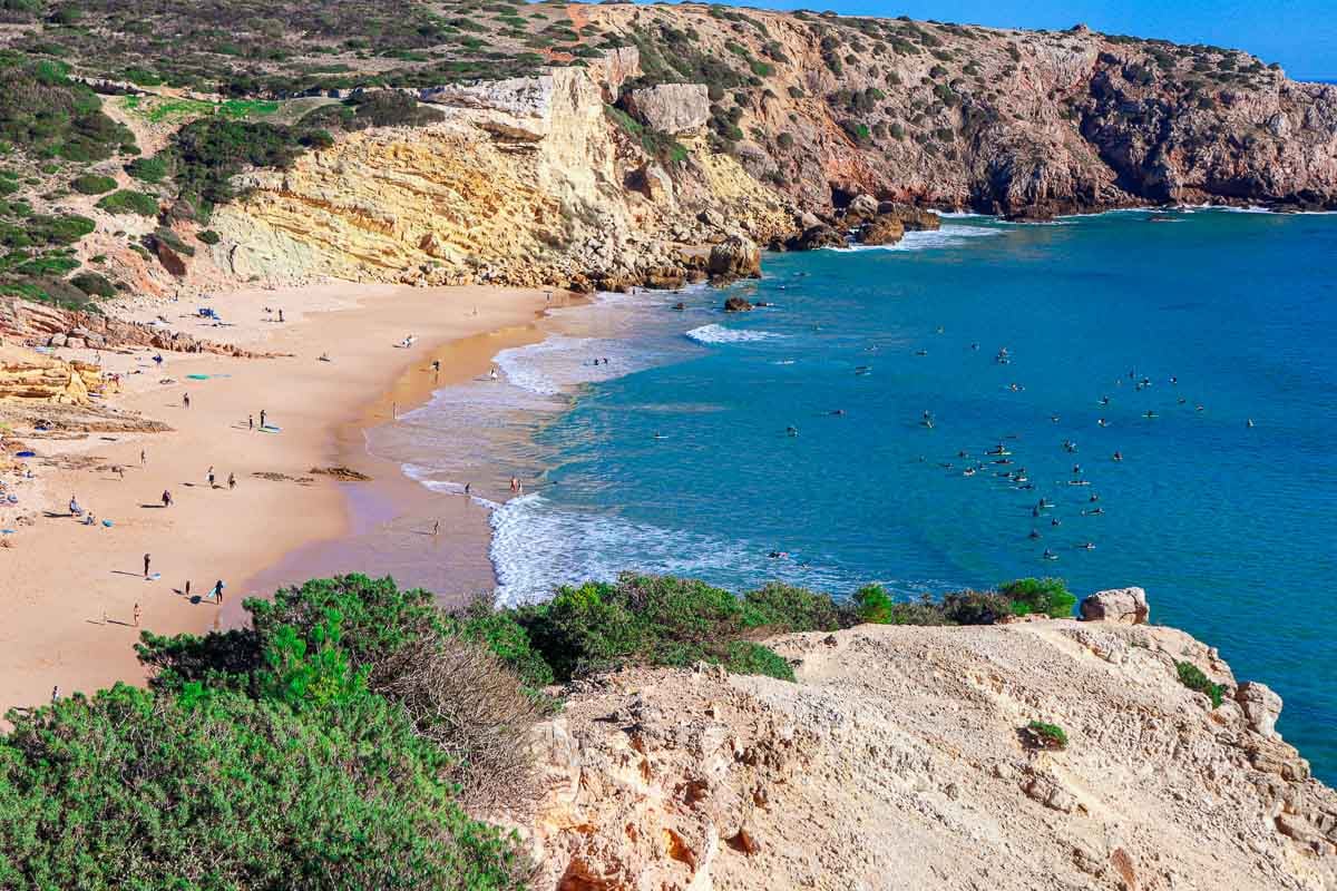
 The beautiful Praia da Maretha in Sagres is the first beach you will see hiking from Sagres to Salema and is a nice place to go for a swim!
The Sagres to Salema route overview
- Total distance – 20 km/12,4 mi
- Time – 5-6 hours
- Total ascent – 533 m
- Total descent – 555 m
- Difficulty – moderate/difficult
- Starting point – the information office in Sagres
- Finishing point – the parking lot at Salema Beach
- Walking route – Sagres – Martinhal Beach – Rebolinhos Beach – Barranco Beach – Ingrina Beach – Zavial Beach – Praia das Furnas – Figueira Beach – Salema.
 Map of the Sagres to Salema hiking trail drawn with a Garmin hiking watch.
The Fishermen´s Trail
The Fisherman’s Trail is a 230 km/143 mi walking route in the south of Portugal and is considered one of the most beautiful coastal hiking routes in the world. The spectacular route takes you past rugged cliffs, sandy beaches, stunning lookout points, charming towns, and the amazing views of the Atlantic ocean never stops. Part of the Rota Vicentina network it is one of the best hikes in the Algarve.

 Gone swimming while hiking on the beach following the Fishermen´s Trail.
GPX File (digital map) for Sagres to Salema Walk
The route is well-marked and easy to follow. You can download the Sagres to Salema hike GPX file here. You can use this digital map on your phone for navigation. Want to know how to use a GPX file for phone navigation?
Route Distance
The total distance of the Sagres to Salema hiking route is 20 km and takes most people between 5 and 8 hours to complete. The trail can be walked in 5 to 6 hours at an average walking pace. Walking at a relaxing pace and making stops for photos and spending some time on the beautiful beaches, 7 to 8 hours is a good time to estimate.
Difficulty of the Sagres to Salema walk
This is a challenging hike of moderate difficulty. We found it the hardest stage on the Fishermen’s Trail. The distance combined with many climbs up and down the cliffs towards Salema made this a demanding stage.
 The elevation profile of the Sagres to Salema hike drawn by my Garmin watch. From here you can see that there are a lot of hills on the hike.
The Trailhead (start) of the Sagres to Salema walking route
The trailhead of the Sagres to Salema hike is at the trail map sign pointing to Salema at the Sagres information office near Mareta Beach.
Walking through Sagres Town
Walking from here you have two options, walk through Sagres town (the official trail) or wander a bit sticking to the ocean. You can walk past Mareta Beach and from the beach walk on the top of the cliffs along the coast through the Ponta da Atalaia lookout point. This is about an extra 2,5 km to walk, but the views of Mareta Beach, Sagres Fortress, and the harbour are really nice. To get back to the official trail head to Pinóquio Café in Rua Cmte Matoso.
 The beautiful Maretha beach in the town of Sagres.
Trail Markings
The Sagres to Salema route is well-marked with blue and green stripes painted on rocks, wooden poles, and trees. Along the trail, you get wooden signs with distances to the next beach or town.
 The clear green and blue markings of the Fishermen´s trail on the Sagres to Salema hiking trail.
Where Does the Trail End?
The trail Sagres to Salema walk ends at the parking lot of Salema Beach. You can continue walking on the Fishermen’s Trail from Salema to Praia da Luz or Praia da Luz to Lagos.
Can the route be walked in both directions?
This trail can be walked in either direction; from Sagres to Salema or from Salema to Sagres. The advantage of walking from Salema to Sagres would be that you walk the difficult part of the route first.
Highlights of the Sagres to Salema walk
The beautiful route mostly hugs the coast offering spectacular views of the Atlantic Ocean. Exploring the rugged cliffs, sandy beaches, dramatic drops, and stunning lookout points offers plenty of highlights. We loved the hidden beaches you discover as you follow this amazing trail.
 Praia do Martinhal located 1.7 km (1 mile) from the start of the trail. You can walk on the beach as part of the Fishermen´s trail. Located near Sagres, in the Bay of Baleeira. This is a beautiful sheltered beach with calm water famous for beautiful limestone islets just off the shore and popular for Scuba diving and snorkeling.
These are some of the beautiful little hidden beaches you will find on the West Coast of the Algarve between Sagres and Salema:
- Martinhal Beach
- Barranco Beach
- Ingrina Beach
- Zavial Beach
- Praia das Furnas
- Figueira Beach
- Salema Beach
When is the best time for walking this route?
With more than 300 sunny days per year in the Algarve you can hike this route all year round. Here is an overview of different hiking conditions at different times of the year.
Spring (April and May) – great time for hiking in the Algarve, warm and sunny days along the coast, many flowers, this is also a good time for birdwatching.
Winter months (November to March) are nice for walking because it doesn’t get too hot and the weather is still pleasant most of the day. You can be unlucky and get a couple of rainy and windy days. In our experience the worst weather is February and March.
Hiking in the summer, (July, August), and the first half of September it can be very hot, don´t forget water, a hat and sun cream. These months are the peak tourist season in the Algarve expect many people and higher prices.
June, the second half of September and October (shoulder seaon) are excellent months for the Fishermen´s trail. Little rain, mostly warm, and sunny conditions with and not too crowded.
 Barranco Beach 7,5 km/4,6 mi from the start of the trail in Sagres. This beautiful sandy beach is a popular place to stop with camper vans.
How to get to Sagres?
Sagres can be reached by public bus from Lisbon or Lagos.
- Lagos – Bus #47 (Vamus Bus) a direct bus from Lagos departs several times per day. From Lagos to Sagres EUR 3, 1 hour. Sagres bus stop at the information office at Jardim de Sagres.
- Lisbon – Direct buses from Sete Rios bus station in Lisbon to Sagres. Lisbon to Sagres travel time by bus 4h30min. Cost around 23 euros per person. See Rede Expressos website.
 Zavial Beach 10,7 km/6,6 mi from the trail head in Sagres is a popular and busy surfing beach with a restaurant about half way to Salema.
Route Description Sagres to Salema hike
- Starting point – information office in Sagres, the trail follows the main street (Rua Cmte Matoso) and at the end of the street (just before Pinóquio Café) turns left following a small street (Rua Jaime Conde).
- 1,7 km/1 mi – Praia do Martinhal. walk on the beach for 300m, the trail goes left past Nortada Beach Bar and then goes back to the beach (you can walk on the beach).
- 2,7 km/1,6 mi – Praia dos Rebolinhos, a small rocky beach.
- Between 2,7 km/1,6 mi and 6,5 km/4 mi – walk inland through the fields.
- 6,5 km/4 mi – a steep downhill.
- 7,5 km/4,6 mi – Barranco beach, a hidden sandy beach and a popular stop for campervans.
- 10 km/6,2 mi – Ingrina Beach, a beautiful, small sandy beach with a restaurant.
- 10,7 km/6,6 mi – Zavial Beach, a very nice beach, popular for surfing, has a restaurant (opens at 11 am, closed on Mondays). Tricky descent to the beach over loose rocks.
- The trail goes accross Zavial beach and continues along the cliffs first with a short steep ascent and then descent. You can walk on the beach instead and get to the trail at the end of it you’ll see a trail on the left going up the cliffs. It’ll save you some energy.
- 13,6 km/8,4 mi – Praia das Furnas, a nice sandy beach with a steep descent from the cliffs. The route continues on to the top of the cliffs and down to the beach pretty much non-stop till the end. In my opinion, it’s the most difficult part of the Sagres to Salema walk.
- Between 13,6 km/8,4 mi and 16,6 km/10,3 mi the trail goes inland on the gravel road over the hills.
- 17 km/10,5 mi – a steep descent to Figueira Beach with a subsequent ascent to the top of the cliffs past the ruins of a small fort.
- 17,5 km/10,8 mi – a steep and tricky descent to Praia Santa with a subsequent ascent.
- 19 km/11,8 mi – first houses of Salema.
- 20 km/12,4 mi – Salema Beach.
 Praia das Furnas 13,6 km/8,4 mi from the start of the trail is a nice sandy beach reached after a steep descent from the cliffs.
What to pack for hiking?
Carry enough water (you can buy more water around half way at Ingrina Beach and Zavial Beach). Take cash for drinks and snacks on the way. Wear sufficient sun protection. Pack for the weather, maybe a towel if you want to go for a swim or a rain jacket if it looks rainy.
Places to stay in Sagres
Places to stay in Salema
| Salema Eco Camp | Salema Beach Village | Casa Da Paz |
Travel bloggers from South Africa
Please visit:
Our Sponsor