

The iconic Laguna de Los Tres hike to the foot of Mt. Fitz Roy (Cerro Fitz Roy) is one of our favorite hikes in Patagonia. Also known as the Fitzroy Hike this strenuous hiking route rewarded us with jaw-dropping views of lakes and mountains. Laguna de Los Tres is a turquoise lake at the base of Mt. Fitz Roy in Los Glaciares National Park close to the village of El Chalten.
 Trekking to the spectacular Laguna de Los Tres from El Chalten Patagonia.
The Mount Fitz Roy hike can be done as a long day hike, or you can camp close to the base of Mount Fitzroy. For a hike that is a bit easier you can consider doing the Laguna Torre hike, another hike with beautiful views from El Chalten. This a fairly flat trek.
El Chalten is the most popular place to stay for trekking in Los Glaciares National Park in Argentian Patagonia. The geographical region Patagonia, at the southern end of South America, belongs to two countries, Argentina and Chile separated by the gigantic Andes Mountains. The W-trek in Torres del Paine National Park is probably the most famous hiking route on the Chilean side and the Laguna de Los Tres hike in Argentina.
If you need some ideas for planning your trip check out our Patagonia itinerary post where you can find samples of 7, 10, and 14-day itineraries.
How Long is the Laguna de Los Tres Hike?
The Laguna de Los Tres hike is a 24 km (15 miles) hike when done from El Chalten. Hiking to Laguna de Los Tres can be done in different ways.
Overnight Hike – The most popular way to do the Laguna de Los Tres Hike is a 2-day, 24-kilometer (15-mile) out-and-back hike, camping one night, allowing you to see the famous sunrise over Fitzroy mountain.
Day Hike – The trail can also be done as a challenging 24 km day hike, 2 steep hills and the long distance of the trail are the main challenges.
Three-Day Loop – You can hike to Laguna de Los Tres as part of a 2 or 3 day 40 km loop (Laguna de los Tres, Mount Fitz Roy, and Laguna Torre).
See our Complete El Chalten Hiking Guide for a complete travel guide.
Camping on the Laguna de Los Tres trail
When doing a 2 or 3-day hike to Laguna de Los Tres there are 2 free campsites where you can stay; Poincenot campground close to Laguna de Los Tres and Camping de Agostini at Laguna Torre. These campsites do not have to be booked. Facilities are basic with dry toilets and potable running water from a stream.
Remember to Register if you are going to camp (it is free).
See our Complete Camping Guide for El Chalten
Laguna de Los Tres Trail route overview (2-Day Hike)
The hike to the lagoon at the base of Mount Fitz Roy gets its name from the viewpoint at the lake of three peaks; Cerro Fitzroy, Cerro Torre, and Poincenot. Laguna de Los Tres Lake of the Three in Spanish.
- Total distance – 24 km (15 miles) round trip (28 km including a Piedras Blancas Glacier side trip)
- Time – 6 – 9 hours
- Total ascent – 800 m
- Difficulty – Moderate
- Starting point – Avenida San Martín, El Chalten
- Finishing point – Out and back trail (El Chalten – Laguna de Los Tres – El Chalten)
- Walking route – El Chalten, Rió de Las Vueltas mirador, Mirador Fitz Roy, Poincenot campsite, Laguna de Los Tres, (Side Trip to Piedras Blancas Glacier Viewpoint), El Chalten

 The small hiker’s village El Chalten in Argentina Patagonia.
Costs of Hiking to Laguna De Los Tres
There is no entrance fee, the Laguna De Los Tres hike is free. Camping is also free at the three campsites inside the park. No booking is necessary.
Where does the Laguna de Los Tres trail start?
You can start walking the Laguna de Los Tres main trail from your accommodation anywhere in the small town of El Chaltén.
The trailhead to Laguna de Los Tres is at the end of Avenida San Martín (GPS pin), where the town of El Chaltén ends, there is a car parking lot (other hikers will probably also be heading this way). A sign indicates the start of the Laguna de Los Tres when you walk through the car park on the edge of town.

 The trailhead to Laguna de Los Tres is at the end of Avenida San Martín where the town of El Chaltén ends
The Laguna de Los Tres Trail route description
Laguna de Los Tres is 12 km (7.5 miles) from the trailhead. The most common route is a 24km (15 miles) out-and-back hike from El Chalten to the lake. This is possible as a long hike in one day, but most people hike the route over 2 days, camping in Campamento Poincenot. To hike from El Chalten to Laguna de Los Tres is round and about a 9-hour return hike, depending on your fitness level. There is a possible side trail to the viewpoint of the Piedras Blancas Glacier that adds about 4km to your hike. Three campsites in the park are connected by hiking trails. You can walk in several different ways staying in these campsites and seeing the highlights of the park.
El Chalten to Campamento Pointcenot (8 km)
Start the hike at the trailhead just outside town at the parking area at the end of Avenida San Martín. Register here if you are going to camp. Registration is free.
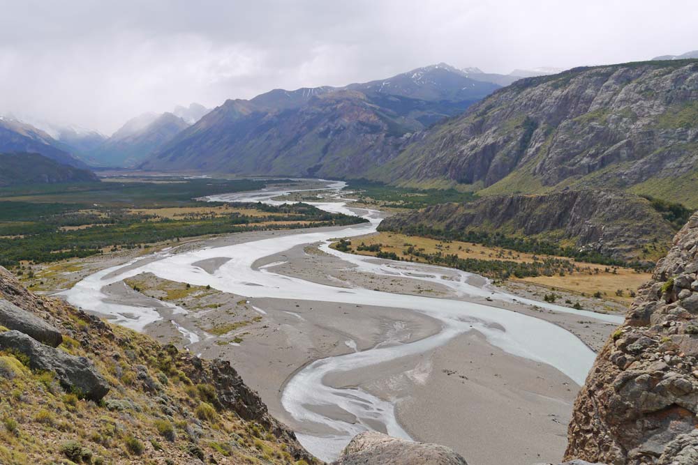
 Start the hike from El Chalten with nice views of the Río de las Vueltas riverbed.
The trail starts with a steep uphill and some steps. In the first kilometer, there are nice views of the Río de las Vueltas riverbed, continuing to the well-signposted Laguna Capri, a beautiful lake with its own campground, this is the first viewpoint. Nice views of Fitz Roy Range here on a clear day. The laguna is 4km about 1 hour and 15 minutes walk from the visitors center.
The popular Camp Poincenot is just over an hour’s hike from Laguna Capri. (about another 4 km) If you are camping this is the end of day one, find a spot to pitch your tent, get some water in the river, and make a cup of coffee! If you are pushing on it is a great spot to take a break before continuing on for about another hour to the campsite to Laguna de Los Tres (3 to 4 km/2.5 miles).

 Campamento Poincenote in Parque Nacional Los Glaciares, El Chalten has basic facilities, no electricity, lights or running water.
Campamento Pointcenot to Laguna de Los Tres (4 km)
After leaving the campsite and crossing Rio Blanco the climbing starts with about 400m to ascend in the last 2 kilometers. This is a strenuous hike. Loose scree is the last hurdle on this challenging hike to reach the lake. The trail leads onto a moraine overlooking the Laguna de Los Tres, with the glaciers, and three massive peaks behind it. The views of the surrounding landscape are truly spectacular.

 Arriving at Laguna de Los Tres with spectacular views of Mt Fitzroy.
Don’t miss the Laguna Sucia a stone’s throw away for another amazing view! To see this beautiful cobalt lake, walk along the well-marked half-a-mile (700m) trail to the left of Laguna de Los Tres to a viewpoint of Laguna Sucia, an amazing lake that is not as well known.
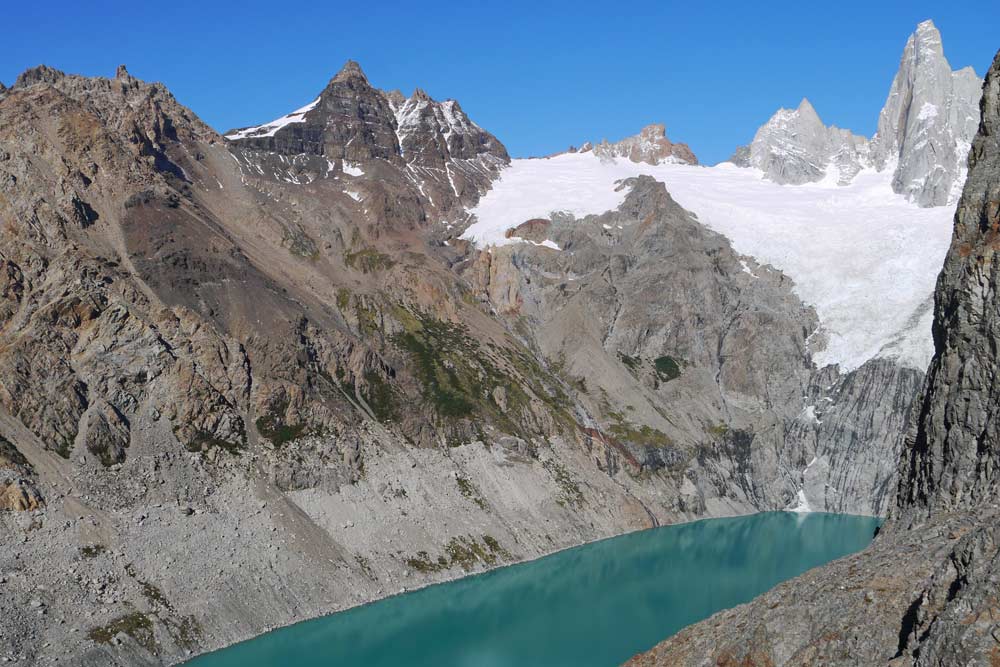
 Don’t miss the beautiful Laguna Sucia just around the corner from Laguna de Los Tres when you do this incredible hike.
Laguna de Los Tres to El Chalten (12 km)
The walk back to El Chalten is fairly easy 12 km with 2 down hills that should take about 3 hours.
Hiking the Laguna de Los Tres Loop
- Total distance – 38 km (24 miles)
- Time – 2 or 3 Days
- Starting point – Avenida San Martín, El Chalten
- Walking route – El Chalten, Rió de Las Vueltas Mirador, Mirador Fitz Roy, Poincenot campground, Laguna de Los Tres, (Side Trip to Piedras Blancas Glacier Viewpoint), Laguna Torre, Camping de Agostini, Mirador del Torre, El Chalten
The Laguna de Los Tres Loop can be hiked as a 2 or 3-day trail. On day 2 instead of heading back the same way to El Chalten, walk to Laguna Torre. To do this as a 3-day trail you can stay at Laguna Torre at Camping de Agostini.
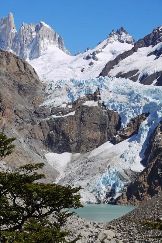
 The Piedras Blancas Glacier Viewpoint is a 5 km detour from the Laguna de Los Tres trail.
2-Day Hike – Doing this loop as a 2-day hike is challenging. You can see both Laguna de Los Tres and Laguna Tore with Cerro Torre in the background.
3-Day Hike – walk from Laguna De Los Tres to Laguna Torre (19 km) camping at Camping de Agostini another free campsite at Laguna Torre. If you do the 3-day hike you can hike to the Mirador Maestri viewpoint of the spectacular Torre Glacier, this is a 5 km detour. On day 3 hike the final 12 km to El Chalten.
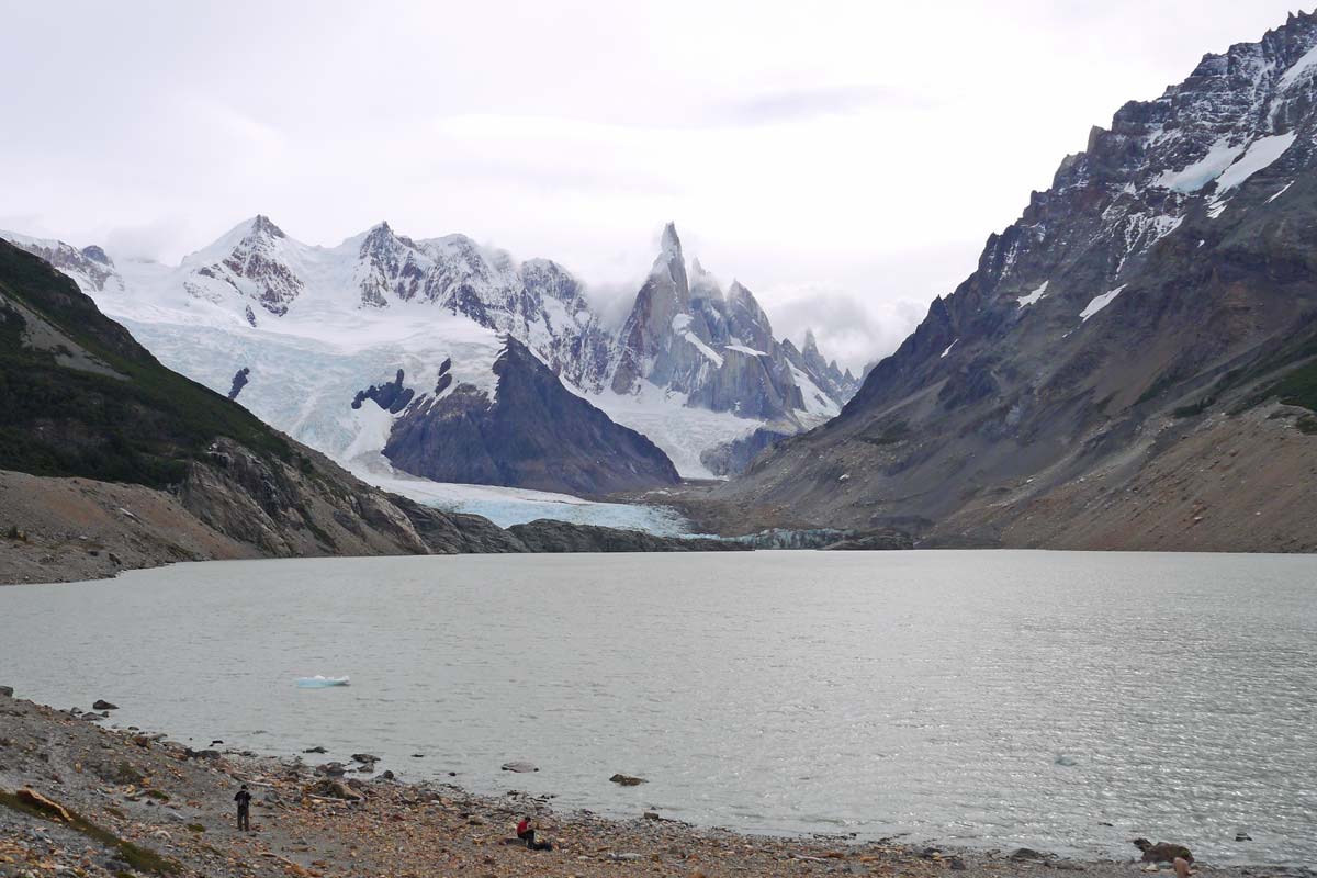
 Laguna Torre with Torre Glacier in the background hiking the Laguna de Los Tres loop.
How difficult is the Laguna de Los Tres Trail?
The Laguna de Los Tres trail is of moderate difficulty with 2 steep climbs, the rest of the trail is fairly flat. The total elevation gain during the hike is 800 meters. How difficult the hike is depends on the route you choose, a 1-day, 2-day, or 3-day hike. Camping for a night makes the distance more manageable, it is also the only way to reach the viewpoint in time to see the beautiful sunrise over Fitz Roy Mountain.

 Getting up early, and making coffee at Laguna de Los Tres, what a breakfast view!
Hike to Laguna de Los Tres Independently
One of the most popular hikes in Los Glaciares National Park you can do this trek in a way to fits your fitness level. The Laguna de Los Tres trek is a fantastic trail to hike independently. The trailhead is easy to find and you can start hiking anywhere in the village of El Chalten. The route is well marked and in season this is a safe hike to do with many other hikers on the trail.
You’ll find a complete packing list for hiking and camping in the region in our Patagonia Packing List.
Hike to Laguna de Los Tres with a Tour
Guided hikes to Mt Fitzroy are very popular, see these tour options:
When to Visit El Chalten
You can visit El Chalten all year round, but when is the best time to visit El Chalten?
Weather-wise the hiking season is in the summer months from October to April, with the best weather from December to March with higher temperatures. It can however get very windy in summer and this is the peak tourist season with higher prices. Camping in strong winds is challenging.
Shoulder season, November and April, is good to avoid the crowds and temperatures are nice for hiking. It is however a bit of a gamble, can be great, but you can have bad luck with wind, rain, and cold weather.
In winter between June and September, it can be cold, the wind is less, but the trails can be inaccessible because of snow.
Accommodation in El Chalten
In season I will advise you to book accommodation ahead to avoid disappointment.
How to Get to El Chalten
El Calafate has the nearest airport, about 220km away, and can be reached from Buenos Aires by plane or bus. The road between El Calafate and El Chaltén is paved in excellent condition and the trip takes 3 hours by bus. There is a daily bus between El Calafate and El Chaltén works all year round, twice per day morning and evening (3 times in the peak season). You can book a bus transfer from El Chalten to El Calafate here.
Buses are quite expensive and people try hitchhiking. If you decide to hitchhike, just get on the road early, we had a long day of very competitive hitchhiking here. We hitchhiked a lot in Patagonia and it was a great way to explore the area and to travel the Carretera Austral.
Travel insurance for hiking in Patagonia
Hiking like any outdoor activity involves a risky part with the possibility of getting an injury.
World Nomads offers simple and flexible travel insurance. Buy at home or while traveling and claim online from anywhere in the world.
What to pack for hiking in El Chalten?
- On a day hike, you might be walking for 9 hours, take 2 liters of water, lunch, and a snack.
- I love my Salomon X Ultra gortex boots, fantastic for all seasons. Keeps mud, snow, and rain out. Comfortable, light, and completely waterproof.
- Ladies model, Alya hikes in Salomon Women’s X Ultra Mid Gortex Boots

 Our Salomon Ultra X mid-height hiking boots.
- Wearing Merino wool socks is the best at keeping your feet dry, and blister-free, and preventing smelly feet. For hiking in Patagonia, I recommend using a Mid-weight Wool Sock – Darn Tough Micro Crew Cushion Hike-Trek Merino Wool Sock (Hike Trek Ladies Sock). Darn Tough is a fantastic brand with a lifetime guarantee on their socks. Danish Endurance Premium Outdoor Hiking Socks (Unisex) is another very good merino wool sock that is easier to get hold of in Europe.
- Hiking poles take a lot of strain on your knees on steep climbs.
- We are very happy with our MSR Hubba Hubba NX – it’s very light (1,3kg), packs small, easy to pitch, waterproof, its shape is great for strong wind and it’s durable. for a middle-price range tent, the MSR Elixir is a good option
- The Osprey Kestrel 48L backpack is a great size for multi-day hikes, the pack is relatively light, fits very comfortably, can open from the top, has a side zipper, breathable back fit, adjustable torso, and comes with a rain cover.
- An inflatable camping pad
- Pack a portable camping stove and a cooking set.
Please follow and like us:

The strong half of Stingy Nomads, a nomadic aquaman that would be happy to spend all his life in the water diving, surfing and spearfishing but often has to compromise with Alya and go hiking instead. Campbell is responsible for all our marine adventures and following them with write-ups. He loves traveling, braai (BBQ in South Africa), red wine and spending the day in a wetsuit.
Please visit:
Our Sponsor